 By 0930 on Saturday 13 November we had rented a car from Pemai car rental for 30 Euros/day and set off for our first tour of the island of La Palma. Our Argentinian friend Alberto from S/V Louanjo joined us for the trip which added to our enjoyment.
 The island is very mountainous, especially the northern half, with one of its main features being the huge Caldera de Tabauriente which is a pear-shaped cloud filled depression.
 From the capital Santa Cruz, where we are moored, we took the LP04 road which snakes its tortuous path through the mountains to the north of the Caldera.
 The first few miles took us through farmed areas and then through the cloud where the vegitation was dominated by pine forests.
 As the road climbed higher, we left the pines behind and entered a surreal area above the clouds where the vegitation became what one would associate with arid regions. The sky became a deep blue.
 On the rim of the caldera, only the rocky peaks were visible above the clouds.
 Jeannette & Margreet decided it was a good spot to greet the sun.
 Around the rim of the crater, there are some of the clearest skies in the world and very little light pollution due to its remoteness - a statistic which has attracted the astronomical researchers from many countries. There are over 20 observatories perched on the rim.
 Some , like the British one above, are robotic telescopes which can be controlled remotely from the host countries.
 Above are two huge mirror telescopes, the MAGIC (Major Atmospheric Gamma-ray Imaging Cherenkov Telescope) Florian Goebel telescopes. They detect particle showers released by cosmic gamma-rays, using the Cherenkov radiation, i.e., faint light radiated by the charged particles in the showers. With a diameter of 17 meters for the reflecting surface, they are the largest in the world. Florian Goebel died aged 35 when he fell 10 meters when fixing a camera on the telescope (info from Wikipedia).
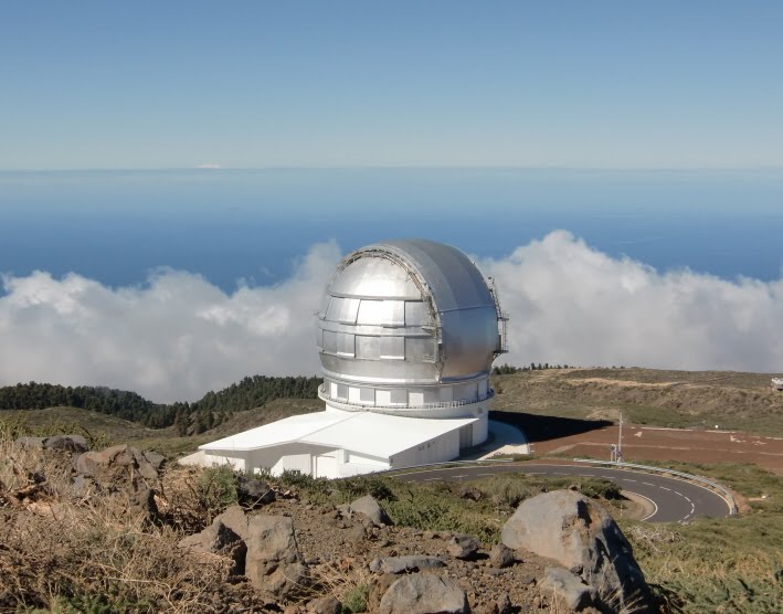
 The highest point on the island is Roque de los Muchados - 2426 meters above sea level, which can, amazingly be reached by car.
 Amazingly, Mount Teide, the 3718 meter high volcanic peak on Tenerife was clearly visible above the cloud some 70 nautical miles away.
 As we descended, the vegitation went through the same changes as on the way up and the temperature steadily increased. We stopped for a picnic overlooking a small vineyard.
 The road suddenly descended the almost vertical sides of the south west end of the Taburiente Caldera as drew near to Puerto Tazacorte. Whereever possible, banana plantations had been planted, some covered with a sort of greenhouse made of netting - similar to those we had seen on Fuerteventura.
 The island of El Hierro, some 50 nmiles away is just visible on the horizon. El Hierro was considered by the ancients to be at the western edge of the known world. Until the International Meridian Conference held Washington DC, USA, in October 1884, Spain's zero Meridian used to pass through Punta Orchilla on the SW tip of El Hierro.
Twenty-five nations participated in the conference. The following were among the resolutions adopted by the conference:
1. That it is the opinion of this Congress that it is desirable to adopt a single prime meridian for all nations, in place of the multiplicity of initial meridians which now exist.
2. That the Conference proposes to the Governments here represented the adoption of the meridian passing through the centre of the transit instrument at the Observatory of Greenwich as the initial meridian for longitude.
3. That from this meridian longitude shall be counted in two directions up to 180 degrees, east longitude being plus and west longitude minus.
Resolution 2, fixing the meridian at Greenwich, was passed 22–1 (San Domingo, now the Dominican Republic, voted against); France and Brazil abstained. The French did not adopt the Greenwich meridian until 1911.[1] (Source - Wikipedia).
 We stopped in Tazacorte for a welcome icecream.

 The strengthening work on the outer mole of the port of Tazacorte can be seen in the distance.
 Close-up of the massive sea wall.
 New peaceful marina of Tazacorte.
 More Bananas
 An interesting light effect in the late afternoon - the sun is low enough in the sky to illuminate the hills under the cloud.
 The Lp02/LP03 road entered a new 2 km tunnel obviating the need to climb back into the clouds to re-reach Santa Cruz.
1 comment:
het is een genoegen om naar de prachtige foto's te kijken vanuit mijn bed.Ik heb namelijk mijn achillespees afgescheurd (totaal).
Gebeurde in ons huis in Turkije om 12 uur en om 15.00 uur lag ik op de operatie-tafel , zijn nu weer thuis in Nederland!Goede vaart en we zien wel waar jullie geland zijn.
Grtjs LNG
Post a Comment